About Nantroseize
The NanTroSEIZE project is a multi-year, multi-expedition coordinated scientific drilling program focused on logging, sampling, and monitoring along a transect offshore the Kii Peninsula, SW Honshu (Figure 1), with the goal of better understanding subduction zone earthquakes. Along this corridor, the accretionary prism is cut by a major out of sequence thrust fault termed the “megasplay” that branches from the décollement ~55 km from the trench, and separates the ~40 km-wide actively deforming outer wedge and an older inner wedge (Figure 2). The Kumano Basin, a large forearc basin infilled by ~2-3 km of Pleistocene and younger mudstones and turbidites, lies above the inner wedge (Figure 2). NanTroSEIZE coring and observatory installations have been undertaken along a transect from the incoming plate, across the outer wedge, and in the Kumano Basin and inner wedge.
Long-term, in situ hydrologic and geophysical measurements in borehole observatories are a central element of NanTroSEIZE, and the Integrated Ocean Drilling Program (IODP) science plan more broadly. These installations provide our only opportunities to establish a presence in the sub-seafloor, to measure in situ processes and properties, and to monitor changing conditions in dynamic tectonic and hydrologic environments. You can find a brief overview of NanTroSEIZE observatory installations to date (ca. 2014) here.
The Site C0002 Observatory
The data archived here are pore pressure measurements from IODP Site C0002, the primary NanTroSEIZE deep riser drillsite location (an overview of the drillsite can be found here). The observatory was deployed in Dec. 2010 as part of IODP Expedition #332 (Figure 3). The installation includes four pore pressure sensors supported by the U.S. National Science Foundation (NSF), installed in concert with a broadband seismometer, tiltmeter, strainmeter, and an array of geophones funded by collaborators at JAMSTEC. The installation comprises a co-located, multi-level hydrologic and geodynamic observatory, at a location directly above the plate boundary near the updip edge of coseismic slip in the 1944 event (where the fault is thought to be interseismically locked), and also above the hypocenters of quasi-regularly occurring very low frequency earthquake swarms on the shallow décollement and/or splay faults (Figures 1-2).
The pore pressure ports monitor the formation within depth intervals at 757-780 mbsf (in the Kumano Basin sediment fill) and 937-980 mbsf (in the upper accretionary prism), and transducers at the wellhead record data at 1 Hz. The hydrostatic seafloor pressure is also recorded for reference. A third pressure port is cemented with the seismometer and strainmeter instrument carrier at 908-917 mbsf, and is not open to the formation. Details of the borehole configuration and sensors are described in the IODP Expedition 332 Summary and Proceedings volumes.
At the wellhead (Figure 4), the dataloggers were operating in a standalone mode from installation through January, 2013, after which they were connected to the Dense Oceanfloor Network system for Earthquakes and Tsunamis (DONET) for real-time data transmission to shore. Data are synced from DONET to this portal every 10 minutes. For questions about the data, or to obtain raw (binary) data from the pressure transducers, please contact us directly.
Figures
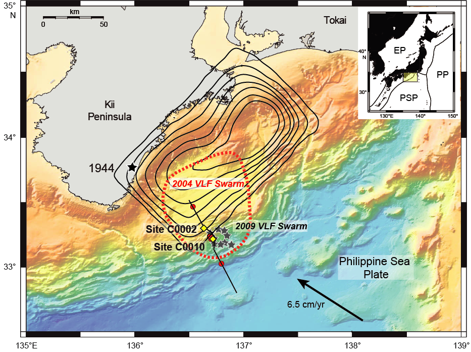
Figure 1: Map showing NanTroSEIZE drillsites, including observatory Sites C0002 and C0010 (yellow). Contours show coseismic slip in the 1944 M 8.2 Tonankai event (0.5 m interval) [Kikuchi et al., 2003]. “Swarms” of very low frequency (VLF) earthquakes observed in 2004 [Ito & Obara, 2006] and 2009 [Sugioka et al., 2012] lie immediately below Sites C0002 and C0010. Location of composite seismic line in Figure 2 is shown in black. EP = Eurasian Plate; PP = Pacific Plate; PSP = Philippine Sea Plate.
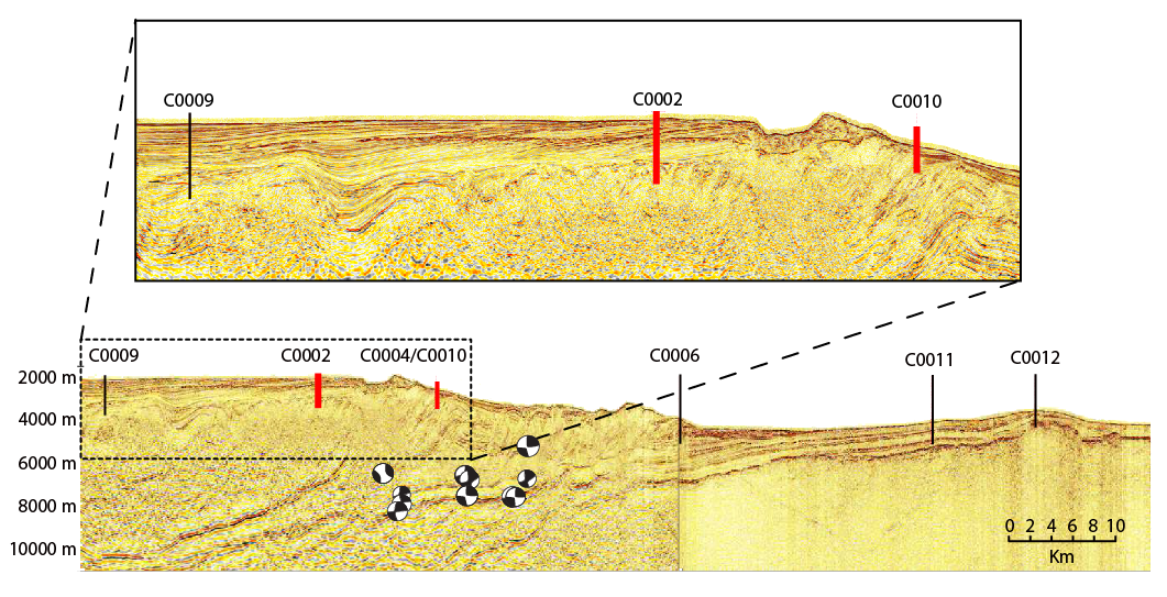
Figure 2: Composite regional seismic line (bottom, location shown in Figure 1) and detailed section (top), showing locations of NanTroSEIZE boreholes. Co-located hydrologic and geodetic/geodynamic borehole observatory is currently installed and operating at Site C0002, and a second is planned for deployment at Site C0010 (both shown in red). Well-located VLF earthquakes with magnitudes of 3.8-4.9 [Sugioka et al., 2012] lie almost immediately below the observatory holes.
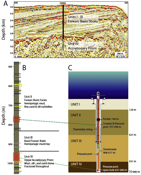
Figure 3. (A) Detailed seismic section and (B) stratigraphic column for Site C0002 [after Ashi et al., 2009]. (C) Schematic showing the borehole completion and observatory [after Kopf et al., 2011]. Pore pressure is monitored in 2 intervals in the formation: the basin section (Unit II) at 757-780 m, and the uppermost accretionary prism (Unit IV) in open hole from 937-980 m. Two additional ports monitor pore pressure at the seafloor as a hydrostatic reference, and within a cemented interval containing the strainmeter, tiltmeter, and seismometer.
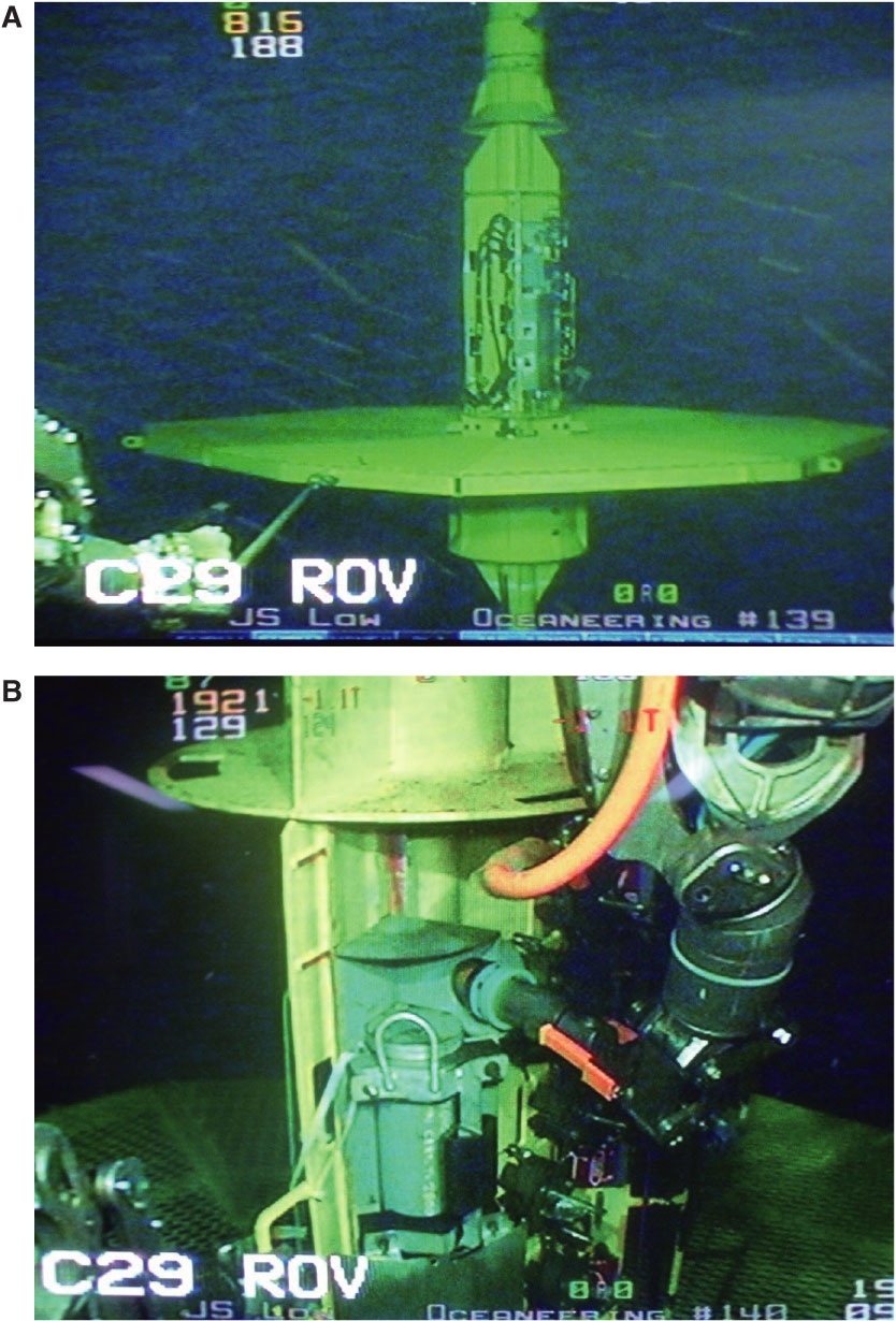
Figure 4: Photos of the Site C0002 wellhead at the seafloor (top) and close-up of the data cables in one of the wellhead instrument bays.
References Cited
Ashi, J., Lallemant, S., Masago, H., and the Expedition 315 Scientists, 2009, Expedition 315 summary. In Kinoshita, M., Tobin, H., Ashi, J., Kimura, G., Lallemant, S., Screaton, E.J., Curewitz, D., Masago, H., Moe, K.T., and the Expedition 314/315/316 Scientists, Proc. IODP, 314/315/316: Washington, DC (Integrated Ocean Drilling Program Management International, Inc.). doi:10.2204/iodp.proc.314315316.121.2009.
Ito, Y., and Obara, K., 2006, Dynamic deformation of the accretionary prism excites very low frequency earthquakes, Geophys. Res. Lett., 33, doi:10.1029/2005GL025270.
Kikuchi, M., M. Nakamura, and K. Yoshikawa, 2003. Source rupture processes of the 1944 Tonankai earthquake and the 1945 Mikawa earthquake derived from low-gain seismograms, Earth, Planets and Space, 55, 159-172.
Kopf, A., Araki, E., Toczko, S., and the Expedition 332 Scientists, 2011b, Proc. IODP, 332: Tokyo (Integrated Ocean Drilling Program Management International, Inc.). doi:10.2204/iodp.proc.332.105.2011.
Sugioka, H., T. Okamoto, T. Nakamura, Y. Ishihara, A. Ito, K. Obana, M. Kinoshita, K. Nakahigashi, M. Shinohara, and Y. Fukao, 2012, Tsunamigenic potential of the shallow subduction plate boundary inferred from slow seismic slip, Nat. Geosci., 5, 414–418, doi:10.1038/ngeo1466.